

Trackbook GPS

Description de Trackbook GPS
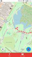
Trackbook is a bare bones app for recording your movements. Trackbook is great for hiking, vacation or workout. Once started it traces your movements on a map. The map data is provided by OpenStreetMap (OSM).
Trackbook is free software. You can find the code on GitHub (https://github.com/y20k/trackbook). GitHub is also a good place to file bugs or even to contribute, if you are interested. Trackbook is published under the MIT open source license. Trackbook uses osmdroid to display the map, which is also free software published under the Apache License.
HOW TO USE TRACKBOOK
+ Start recording movements
Press the big blue button to start recording your movements. Trackbook will continuously drop markers onto the map.
+ Stop recording movements
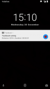
To stop your recording press the big blue button again or use the stop button in the Trackbook's notification. You can look at the recorded movements on the map afterwards.
+ Save last recording
Stop the recording and then tap again on the big blue button. It will offer an option to "Save and Clear". Trackbook stores saved recordings as plaintext JSON files in the directory /Android/data/org.y20k.trackbook/files/tracks.
+ Clear main map
Stop the recording and then tap again on the big blue button. Chose the option "Clear", if you just want to clear the map without saving your recording.
+ Statistics and Last Tracks
Peek into Trackbook's notification to see the distance and duration of your current recording. Switch to the "Last Tracks" view to review your last recordings. Trackbook stores up to 25 recent tracks. Pull up the statistics to see distance and duration of that recording, as well as the steps taken.
+ GPX Export
Saved recordings can be exported as GPX (GPS Exchange Format) from the "Last Tracks" view. Just tap the export icon next to the track selection menu.
+ How does Trackbook measure distance?
Trackbook calculates the distance between markers and adds them up.
WHICH PERMISSIONS DOES TRACKBOOK NEED?
+ Permission "INTERNET"
Trackbook needs to download map data from OpenStreetMap servers and therefore needs access to the internet.
+ Permission "ACCESS_NETWORK_STATE" and "ACCESS_WIFI_STATE"
Trackbook uses osmdroid to draw its maps. osmdroid needs to know the current state of your device’s connectivity.
+ Permission "ACCESS_COARSE_LOCATION" and "ACCESS_FINE_LOCATION"
Trackbook needs accurate GPS location data to be able to record your movements. If the GPS data is not available or not accurate enough Trackbook uses location data from cell tower and WiFi triangulation.
+ Permission "WRITE_EXTERNAL_STORAGE"
Trackbook uses osmdroid, which caches map tiles on Android's external storage. You can find the map cache in the "osmdroid" folder on the top level of the user-facing file system.
Trackbook est une application nue os pour enregistrer vos mouvements. Trackbook est idéal pour la randonnée, de vacances ou d'entraînement. Une fois commencé trace vos déplacements sur une carte. Les données de la carte sont fournies par OpenStreetMap (OSM).
Trackbook est un logiciel libre. Vous pouvez trouver le code sur GitHub (https://github.com/y20k/trackbook). GitHub est également un bon endroit pour déposer des bugs ou même de contribuer, si vous êtes intéressé. Trackbook est publié sous la licence open source MIT. Trackbook utilise osmdroid pour afficher la carte, qui est aussi un logiciel libre publié sous licence Apache.
COMMENT UTILISER TRACKBOOK
+ Début mouvements d'enregistrement
Appuyez sur le gros bouton bleu pour commencer à enregistrer vos mouvements. Trackbook baissera en continu des marqueurs sur la carte.
+ mouvements d'enregistrement d'arrêt
Pour arrêter votre enregistrement, appuyez sur le gros bouton bleu à nouveau ou utiliser le bouton d'arrêt dans la notification de la Trackbook. Vous pouvez regarder les mouvements enregistrés sur la carte par la suite.
+ Enregistrer dernier enregistrement
Arrêtez l'enregistrement, puis appuyez à nouveau sur le grand bouton bleu. Il offrira une option « Save and Clear ». magasins Trackbook enregistrés enregistrements sous forme de fichiers JSON dans le texte en clair /Android/data/org.y20k.trackbook/files/tracks d'annuaire.
+ Effacer la carte principale
Arrêtez l'enregistrement, puis appuyez à nouveau sur le grand bouton bleu. Choisissez l'option « Effacer », si vous voulez juste effacer la carte sans enregistrer votre enregistrement.
+ Statistiques et Derniers titres
Pénétrez dans la notification de Trackbook pour voir la distance et la durée de l'enregistrement en cours. Passer à la vue « Last Tracks » pour revoir vos derniers enregistrements. magasins Trackbook jusqu'à 25 pistes récentes. Tirez les statistiques pour voir la distance et la durée de cet enregistrement, ainsi que les mesures prises.
+ GPX Export
enregistrements sauvegardés peuvent être exportés sous forme GPX (GPS Exchange Format) de la vue « Last Tracks ». Il suffit de taper sur l'icône d'exportation à côté du menu de sélection de piste.
+ Comment mesurer la distance Trackbook?
Trackbook calcule la distance entre les marqueurs et les additionne.
AUTORISATIONS QUI NE TRACKBOOK BESOIN?
+ L'autorisation "INTERNET"
Trackbook doit télécharger les données cartographiques de serveurs OpenStreetMap et doit donc l'accès à Internet.
+ Permission "ACCESS_NETWORK_STATE" et "ACCESS_WIFI_STATE"
Trackbook utilise osmdroid pour dessiner ses cartes. osmdroid a besoin de connaître l'état actuel de la connectivité de votre appareil.
+ Permission "ACCESS_COARSE_LOCATION" et "ACCESS_FINE_LOCATION"
Trackbook a besoin de données de localisation GPS précises pour être en mesure d'enregistrer vos mouvements. Si les données GPS ne sont pas disponibles ou pas assez précis Trackbook utilise des données de localisation de la tour cellulaire et triangulation WiFi.
+ Permission "WRITE_EXTERNAL_STORAGE"
Trackbook utilise osmdroid, qui met en cache les tuiles de carte sur le stockage externe Android. Vous pouvez trouver le cache de carte dans le dossier « osmdroid » au niveau supérieur du système de fichiers orienté vers l'utilisateur.


